Projection tools#
This section describes projection tools that are common to Rasters and Vectors, and facilitate
geospatial analysis.
Get a metric coordinate system#
A local metric coordinate system can be estimated for both Rasters and Vectors through the
get_metric_crs() function.
The metric system returned can be either “universal” (zone of the Universal Transverse Mercator or Universal Polar Stereographic system), or “custom”
(Mercator or Polar projection centered on the Raster or Vector).
import geoutils as gu

# Initiate a raster from disk
rast = gu.Raster(gu.examples.get_path("exploradores_aster_dem"))
rast.info()

# Estimate a universal metric CRS for the raster
rast.get_metric_crs()
Driver:               GTiff
Opened from file:     /home/docs/checkouts/readthedocs.org/user_builds/geoutils/checkouts/stable/examples/data/Exploradores_ASTER/AST_L1A_00303182012144228_Z.tif
Filename:             /home/docs/checkouts/readthedocs.org/user_builds/geoutils/checkouts/stable/examples/data/Exploradores_ASTER/AST_L1A_00303182012144228_Z.tif
Loaded?               False
Modified since load?  False
Grid size:                 539, 618
Number of bands:      1
Data types:           float32
Coordinate system:    ['EPSG:32718']
Nodata value:         -9999.0
Pixel interpretation: Area
Pixel size:           30.0, 30.0
Upper left corner:    627175.0, 4833545.0
Lower right corner:   643345.0, 4852085.0
<Projected CRS: EPSG:32718>
Name: WGS 84 / UTM zone 18S
Axis Info [cartesian]:
- E[east]: Easting (metre)
- N[north]: Northing (metre)
Area of Use:
- name: Between 78°W and 72°W, southern hemisphere between 80°S and equator, onshore and offshore. Argentina. Brazil. Chile. Colombia. Ecuador. Peru.
- bounds: (-78.0, -80.0, -72.0, 0.0)
Coordinate Operation:
- name: UTM zone 18S
- method: Transverse Mercator
Datum: World Geodetic System 1984 ensemble
- Ellipsoid: WGS 84
- Prime Meridian: Greenwich
Get projected bounds#
Projected bounds can be directly derived from both Rasters and Vectors through the
get_bounds_projected() function.
# Get raster bounds in geographic CRS by passing its EPSG code
rast.get_bounds_projected(4326)
BoundingBox(left=-73.34341974540035, bottom=-46.639587475004994, right=-73.1271672077634, top=-46.469563567694934)
Important
When projecting to a new CRS, the footprint shape of the data is generally deformed. To account for this, use get_footprint_projected() described below.
Get projected footprint#
A projected footprint can be derived from both Rasters and Vectors through the
get_footprint_projected() function.
For this, the original rectangular footprint polygon lines are densified to respect the deformation during reprojection.
# Get raster footprint in geographic CRS
rast_footprint = rast.get_footprint_projected(4326)

rast_footprint.plot()
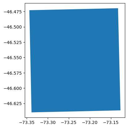
This is for instance useful to check for intersection with other data.